Share this page:
For at least 450 years since its previous recorded eruption, the volcano Mount Pinatubo nestled peacefully among the Zambales Mountains, in the province of Pampanga, north of Manila.
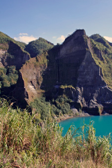
Peaceful again after the 1991 eruption:
lake in the crater of Mt. Pinatubo,
Luzon, Philippines
On 12 June 1991 Mt. Pinatubo erupted with one of the worst and most violent eruptions seen in the twentieth century. It blew itself apart, blasting out seven cubic km of ash and rock and a column of gaseous emissions rising 40 km into the sky.
The shockwaves of the explosions of the eruptions were felt as far away as the Visayas (central Philippines).
Pinatubo rained a hail of fine ash and stones surrounding landscape, towns (like Angeles) and military bases (Clark Air Field and Subic Naval Base). As a result, thousands of hectares of farmland were lost and a number of towns and many villages had to be abandoned.
Manila did not escape: its streets were covered with ash and its airport its airport closed for days.
By bad timing, a typhoon struck Luzon soon after the eruption, turning the volcanic ash and mud into lahar (mobile volcanic mud), which rolled down the mountainsides and river valleys like an express train, engulfing towns, villages, farmland and houses with lethal results.
Over 20 million tons of sulphur dioxide gas were spewed into the atmosphere. As a result the skies turned red for a number of months and red skies caused by Pinatubo's emissions could be seen as far away as Hawaii (see photo below).

"Volcanic sunset." A sunset in Hawaii influenced by volcanic eruption of Mt. Pinatubo in 1991.
Even though seismologists picked up the early warning signs of the 1991 Pinatubo eruption, more than 1,000 people were killed. A million people were displaced with numbers of those leaving to live in Manila.
To this day, large deposits of lahar lie for large distances around the volcano. These deposits, when eroded, produce a fantastic lunar-like landscape. Many tourists travel to visit and trek through the lahar landscape and its weird canyons.
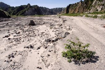
Volcanic landscape:
a valley of ash and volcanic rock leading to Mt Pinatubo
Another major Pinatubo eruption occured on 21 September 1992.
Mt. Pinatubo now appears tranquil, but it could erupt again at any time and meanwhile the lahar starts flowing again with each rainy season, making any permanent agriculture in the area a risky proposition.
Share this page:
Author: David Paul Wagner
(David Paul Wagner on Google+)