Formerly known as Zubu, Cebu was the first island visited by the Spanish explorer, Ferdinand Magellan, in 1521.
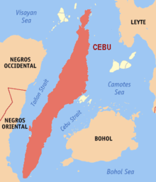
Cebu is a long, narrow island. It is 225 kilometers (140 miles) long, and is surrounded by 167 other, smaller islands. It has a long central mountain range.
Unfortunately, almost all of Cebu island's natural forest has long gone; but there are still numerous beautiful beaches (for example, the beaches at Mactan Island, at Malapascua Island and at Bantayan Island, each of these islands being just off the coast of Cebu island), coral reefs and offshore islands (such as the Camotes Islands) to visit.
Cebu island also also interesting relics from the Spanish colonial era, such as the old Spanish town of Carcar.
The island has five main cities: Cebu City, Toledo, Manadaue, Danao, and Lapu-Lapu. These are all located in the fertile narrow strip of lowland that fringes the coastline -- with the exception of the city of Lapu-Lapu which is actually on the small island of Mactan just offshore from Cebu island.
The largest city on Cebu island is Cebu City. Cebu City is the oldest city in the Philippines and previously was the country's capital. Today Cebu City is the second-largest city in the Philippines after Manila. Read more about Cebu City...
Cebuano, the language of Cebu, is the second largest language in the Philippines after Tagalog (Pilipino).
In Lapu-Lapu City on Mactan Island, you may visit the Mactan Shrine (with the Lapu Lapu Shrine and Magellan Shrine).
Share this page:
Related Pages
Cebu City
Author: David Paul Wagner
(David Paul Wagner on Google+)